
Bar-headed Goose
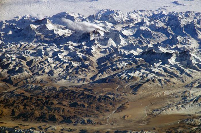
View of the Himalayas, including Everest and Makalu, from the International Space Station.
Downloaded from NASA Earth Observatory, March 30, 2009.
Image coutesty NASA.
You are looking to the south from 200 nautical miles (360 km) above the ground, across an 80 mile (130 km) width of the Himalayas. According to NASA, "the summits of Makalu [left (8,462 meters; 27,765 feet)] and Everest [right (8,850 meters; 29,035 feet)] are at the heights typically flown by commercial aircraft."
 Larger image
Composite panorama of entire Himalaya
Larger image with names of selected peaks Image courtesy NASA and Janderk Jan Derk, aquired from Wikimedia Commons http://commons.wikimedia.org/wiki/File:Himalaya_annotated.jpg on March 30, 2009.
Image coutesty NASA.
You are looking to the south from 200 nautical miles (360 km) above the ground, across an 80 mile (130 km) width of the Himalayas. According to NASA, "the summits of Makalu [left (8,462 meters; 27,765 feet)] and Everest [right (8,850 meters; 29,035 feet)] are at the heights typically flown by commercial aircraft."
Questions for thought
- Where will the downtown ballpark be built?
- Where is Point Loma?
- Where is North Island and what is different about it today?
- What are the small islands on the upper left horizon?
Related resources
-
Hatfield the Rainmaker
Historical maps (such as the one shown above), photos, sound recordings and more. Search for materials from your community.
Library of Congress
-
Panoramic Maps - 1847-1929
The kinds of map shown above is a panoramic map. It's an aerial-oblique view that shows sinificant features although not to scale. Less commonly used today, but still very useful and informative.
Library of Congress