Earth science that relates
Please note that content and links are provided for convenience only. While we do our best to check the quality of our content, we cannot guarantee that it is always correct. We try our best to correct errors as soon as they are brought to our attention so please let us know if you find an error. Hyperlinks that Earthguide provides to external websites do not imply official Earthguide endorsement of, or responsibility for, the content contained on those sites. Links are provided as a service to the user, and Earthguide does not retain editorial control over them. No endorsement of a product or a point-of-view should be inferred.
Key resources
Online Seismic Risk Maps
What is the risk of earthquake-triggered landslide and liquefaction where you live?
(Online maps are not available for most areas south of Orange County yet. Fast internet suggested.)
Map examples
• Prelim maps -
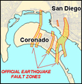
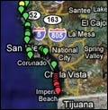
Pt. Loma
• S. California.
• N. California.
• Online map viewer
What is the risk of earthquake-triggered landslide and liquefaction where you live?
(Online maps are not available for most areas south of Orange County yet. Fast internet suggested.)
Map examples
• Prelim maps -
Pt. Loma
• S. California.
• N. California.
• Online map viewer

Links
California Seismic Safety Commission
"The Commission investigates earthquakes, researches earthquake-related issues and reports, and recommends to the Governor and Legislature policies and programs needed to reduce earthquake risk. Among the duties of the Commission are:
- excerpt from their website November 29, 2007
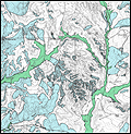
California Geological Survey - Seismic Hazards Zonation Program
Seismic hazard zones map for San Juan Capistrano.
Similar maps for San Diego and Imperial Counties are not yet available.
This agency produces seismic hazard maps for California. A hazard is ... such as
Detailed maps are currently available for the Bay Area south of the Golden Gate along the San Andreas , and mostly Los Angeles, Ventura and Orange Counties in southern California. Detailed maps for San Diego and Imperial Counties are not available yet. The southernmost maps are currently being produced for the area near Temecula.
California Department of Conservation
"The Commission investigates earthquakes, researches earthquake-related issues and reports, and recommends to the Governor and Legislature policies and programs needed to reduce earthquake risk. Among the duties of the Commission are:
- excerpt from their website November 29, 2007
- Managing California's Earthquake Hazards Reduction Program
- Reviewing seismic activities funded by the State
- Providing a consistent policy direction for earthquake-related programs for agencies at all government levels
- Proposing and reviewing earthquake-related legislation
- Conducting public hearings on seismic safety issues
- Recommending earthquake safety programs to governmental agencies and the private sector
- Investigating and evaluating earthquake damage and reconstruction efforts following damaging earthquakes"
California Geological Survey - Seismic Hazards Zonation Program
Seismic hazard zones map for San Juan Capistrano.
Similar maps for San Diego and Imperial Counties are not yet available.
Detailed maps are currently available for the Bay Area south of the Golden Gate along the San Andreas , and mostly Los Angeles, Ventura and Orange Counties in southern California. Detailed maps for San Diego and Imperial Counties are not available yet. The southernmost maps are currently being produced for the area near Temecula.
California Department of Conservation
©2007-2008 by Earthguide
at Scripps Institution of Oceanography
All rights reserved.