
Surface Relief Map - Southern California Bight
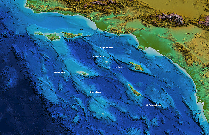
Map Courtesy C. Goldfinger and J. Chaytor, OSU.
[Legend not available.]
Future plans: Mark out of names of basins, Patton escarpment, islands, Point Conception, surface ocean circulation
[Legend not available.]
Future plans: Mark out of names of basins, Patton escarpment, islands, Point Conception, surface ocean circulation
What is the Southern California Bight?
The Southern California Bight (SCB) is the name given to the coastal and offshore area "between Point Conception on the Santa Barbara County coast and a point just south of the United States - Mexico border." [1] Point Conception marks the boundary between southern and central California.
This area is distinguished by unique geography, climate and life because of the major bend in the coast. To the north, the California coast runs north-south, but in the area of the SCB, the coast curves from northwest to southeast.
The SCB consists of 1) the area of the Pacific Ocean between the curving coastline and the edge of the continent at the base of the Patton escarpment (Southern California Borderland), and 2) the adjacent area of land influenced by coastal waters.
In general usage, the term "bight" refers to a curve or bend in a shoreline or coastline.
Important conditions in the SCB include:
- The location of the major surface ocean current, the California Current (an eastern boundary current), away from the coast. Instead of touching the coastline, the California Current usually runs southeastward along the edge of the Patton escarpment and misses the coast.
- Closer to the coast, surface waters often circulate northward. The northward circulating current is called the Southern California Countercurrent (or Davidson Current).
- The presence of many offshore islands.
- The presence of many intervening basins that have depths much greater than typical areas of continental shelf on the east coast of North America (passive continental margins).
- The presence of many faults.
- Milder coastal climates than central or northern California with less rainfall.
- High biodiversity
Questions for thought
- Which are the Channel Islands?
- Where is the edge of the continental shelf?
- Which side of San Clemente Island is steeper and why?
Related resources
-
Data Products and Modeling: Southern California Coastal Ocean Observing System (SCCOOS)
"SCCOOS brings together coastal observations in the Southern California Bight to provide information necessary to address issues in climate change, ecosystem preservation and management, coastal water quality, maritime operations, coastal hazards and national security."
SCCOOS
References cited
- Dailey, M. D., Reish, D. J., Anderson, J. W. (editors), 1993. Ecology of the Southern California Bight: A Synthesis and Interpretation. University of California Press, Berekely / Los Angeles / London, 926 pp.