|
Faulting
Transform faults
 Just south of the mountain runs the Atlantis Transform, an example of another kind of fault. "Transform faults" evolved because the Mid-Atlantic Ridge is thought to have originally fractured jaggedly along the ocean floor rather than following a straight path. As a result, some sections of the spreading ridge are offset from adjacent sections.
Fig. 2. Bathymetric map of Mid-Atlantic Ridge that shows how relatively straight sections are offset from each other. Instead of a continuous curvy line of mountains, the shape of the Mid-Atlantic Ridge is formed of shorter straight sections that are staggered. The Mid-Atlantic Ridge trends NW-SE in this image. The lines running SW-NE are fracture zones and transform faults.
And the new crust moving off of one section slides separately from crust moving off the next. That disjunction forms an earthquake-prone fault, where crust moves in the opposite direction between the two offsets.
Deciphering faults between the different blocks of crust suspected to make up the mountain itself could be crucial to solving the mystery of how this massif formed.
Flash: Strike-Strip Fault
A transform fault is a special kind of strike-slip fault associated with the line between two offset ridge segments on mid ocean ridges.
http://earthguide.ucsd.edu/mar/nov28/transform.html
Normal faults
Two different kinds of faults are possible when blocks are of different heights. One is a "normal fault," where a higher block is climbing up in relation to the lower one. "Thrust faults" are the opposite of normal; there it's the lower block that is moving up.
To help in their problem solving, scientists create working hypotheses to test against the evidence they collect. One working hypothesis is that this mountain's tallest part, a north-south pointing ridge more than 3,660 meters (12,000 feet) above the ocean floor, is the upwardly moving block of a normal fault.
Flash: Normal Fault
In a normal fault, the block above the fault plane moves down. A detachment fault is a special kind of normal fault.
http://earthguide.ucsd.edu/mar/nov28/normal.html
Flash: Reverse Fault
A thrust fault is a special kind of reverse fault where the angle of the fault is close to horizontal.
http://earthguide.ucsd.edu/mar/nov28/reverse.html
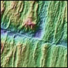
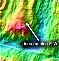 Along the ridge's crest are a series of furrow-like corrugations that point east-west. Those corrugations dip towards a back-tilted ridge that is lower than the first one. Looking at the bathymetric map made by sonar returns during Blackman's and Cann's earlier 1996 expedition, it's easy to envision those furrows as the tracks left on the higher block as it pushes out from under the lower one.
Fig. 3. The east-west running features are the "corrugations."
Underground, the outwardly moving higher block's roots could extend east towards the Mid-Atlantic Ridge, a geological example of Sky Dome-style mechanics, Cann added. In terms used by geologists, the taller block would be a "footwall" that has been forced to rise from its original position below the shorter one, originally the "hanging wall."
In the process, material from deep within the mantle may have also been pushed up. That would explain why mantle-derived rocks like serpentinites have been recovered from the risen footwall's south face during geological dredging operations.
Cann strongly suspects this normal fault becomes a detachment fault underground at the ridge's plate separation zone. Perhaps such atypical behavior resulted from a less than normal amount of magma production there within the past couple of million years.
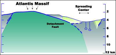 Fig. 4. Cross-section of Atlantis massif showing possible underground fault configuration.
|
A key question is how shallowly the fault dips below the surface. If its dipping angle is exceptionally low - perhaps "20, 10, 5 degrees or even absolutely horizontal," Cann said - it would resemble faults found in "basin-and-range" topographies of the Southwestern United States, where the crust is also believed to have spread apart a much longer time ago.
During the 1980s, Karson found such shallow normal faults further south long the Mid-Atlantic Ridge near the Kane Transform, where there are also underwater massifs similar to this one. He also sees similarities to the dry-land geology of the basin-and-range. "I saw huge, flat faulting surfaces," Karson recalls. "I saw extreme stretching."
The possibilities made Karson, Cann and Blackman all converge for this cruise, as did basin-and-range expert Barbara John and Timothy Schroeder, her graduate student at the University of Wyoming.
Link: Structural Geology and Tectonics
Images from Karson's work at the Kane Transform:
http://www.eos.duke.edu/Research/struct/MAR.html
Today's pages:
The Moving Earth | Faulting | DSL-120 and ARGO-II | Bringing Out Alvin | Thanksgiving Day

|

|
|