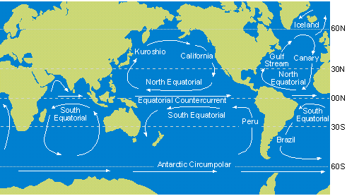
General circulation of the ocean - (n.)
When studying the map of temperature distributions in surface waters of the world ocean, it will be noted that the lines of equal temperature (isotherms) do not follow latitudes entirely faithfully, but are deflected especially in coastal regions. This deflection of isotherms results from surface currents, especially from boundary currents at the edges of the ocean. Surface currents tend to follow surface winds. The winds, in turn, are part of the atmospheric convection system set up by the sun's radiation (atmospheric circulation). The most important wind belts are the trade-winds on either side of the equator, and the west winds or westerlies in mid-latitudes. The trades blow from the east, the westerlies from the west. Since the ocean basins are bounded by land, the currents corresponding to the trade winds and westerlies cannot run around the globe, but close to form large central gyres. See figure below.
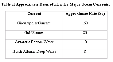
The central gyres dominate the surface circulation patterns of all oceans, except in the Arctic and Antarctic regions. Since there is no barrier to zonal flow in the Antarctic, water flows around the Earth in the great circumpolar current. This is the greatest current in the ocean, about twice as big as the Gulf Stream. In involves not only surface waters, but reaches several miles down. The Gulf Stream itself is also impressive: it has velocities up to 4 knots (about a person’s jogging speed) and transports some 100 million tons of water per second: more than one hundred times the outflow of all the world's rivers combined.
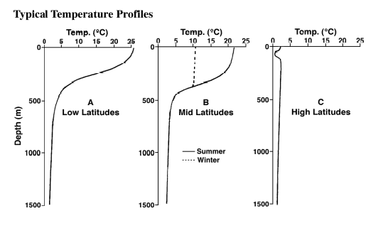
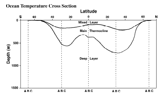
Surface currents move water in the uppermost layer of the oceans. Over most of the oceans (except at high latitudes), a thin layer of warm surface waters overlies the much colder deep waters. The zone of abrupt temperature decrease, as we pass from surface to deep water, is called the thermocline and typically lies between depths of one hundred to one thousand meters.
The circulation of the cold water sphere is poorly known. The water is cold because it "originated" in high latitudes, where the surface waters these in cold regions were cooled, sank, and filled up the deep ocean basins. This process is constantly happening, and without it the abyssal waters would be warm in a few thousand years from the Earth's heat flow through the ocean floor. If waters sink at high latitudes, they must rise at low latitudes. They do so at an overall rate of about 1 cm/day. Most of the abyssal bottom water of the world ocean "originates" ( i.e. sinks from the surface) around Antarctica. The other important deep water source is the northernmost North Atlantic (the Norwegian Sea and Labrador Sea). This is know from mapping the temperature and oxygen content of near-bottom water. As the water moves away from its surface source (i.e. as it "ages") it gradually warms. Also, it slowly loses oxygen because of the respiration of organisms in the deep sea. Thus, "young" water is cold and oxygen-rich, "old" water is less cold and has less oxygen. Most of the deep water in the Atlantic is young, while that of the North Pacific is old.