| |
Calspace Courses
Climate Change · Part One
Climate Change 1 Syllabus
1.0 - Introduction
2.0 - The Earth's Natural Greenhouse Effect
3.0 - The Greenhouse Gases
4.0 - CO2 Emissions
5.0 - The Earth's Carbon Reservoirs
6.0 - Carbon Cycling: Some Examples
7.0 - Climate and Weather
8.0 - Global Wind Systems
9.0 Clouds, Storms and Climates
· 9.1 - Cloud Formation and Climate
· 9.2 - Hurricanes and Global Warming
10.0 - Global Ocean Circulation
11.0 - El Niño and the Southern Oscillation
12.0 - Outlook for the Future
Climate Change · Part Two
Introduction to Astronomy
Life in the Universe
Glossary: Climate Change
Glossary: Astronomy
Glossary: Life in Universe
|
|
Hurricanes and Global Warming
What are Hurricanes?
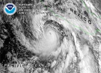
Pacific Hurricane, off Mexico (June 21, 2000) (From: NOAA) |
Hurricanes are large tropical cyclones, and few other weather phenomena attract more attention in the news. Hurricanes form when rapid heat transfer from the tropical sea surface to the atmosphere combines with the Coriolis force to produce giant whirlwinds with wind speeds exceeding 75 mph. Hurricanes are known as typhoons in the Far East and are called cyclones in India. Coastal inhabitants in the Gulf region and the Atlantic seaboard follow their course with trepidation. The satellite photos below show two hurricanes – the one in the Pacific is Hurricane Carlotta, while the off the coast of South Carolina is Hurricane Florence.
Formation of a Hurricane
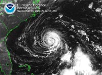
Atlantic Hurricane, off the coast of South Carolina (September 13, 2000) (From: NOAA) |
At the center of a hurricane is a region of rapidly rising air causing a low atmospheric pressure zone. Air moves in at sea level to replace the deficit and is deflected by the Coriolis force, into cyclonic motion that is counter-clockwise in the northern hemisphere (Can you follow which way the air is moving in the satellite photos above?). Friction slows the wind, thus slightly weakening the Coriolis force and allowing the incoming air to gradually spiral inwards towards the low pressure center of the hurricane. This low level air continuously picks up water vapor from the sea as it spirals inward and it brings enormous amounts of latent heat from all around. Near the center the air rises in a series of cumulus convective systems that are wrapped in lines around the central eye of the hurricane.
As the moist air rises within the low pressure center, it cools sufficiently so that the water vapor condenses to form heavy rains. At condensation, all the latent heat that was taken from the ocean and is locked up within the water vapor is now transferred to the air making it ever warmer and lighter. Thus the air in the center of the hurricane is lighter than the air outside, and atmospheric pressure is lower in the center than it is outside. It is this pressure difference that keeps driving new moisture-laden low-level air into the center of the hurricane, thus enabling the hurricane to continue its existence. When the hurricane passes over colder ocean regions or over land, its source of water vapor "fuel" is cut off and it often weakens appreciably.
Caribbean Hurricanes
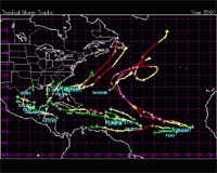
Tropical storm tracks in the Atlanitc and Carribean for 2000. Note how the storms follow the trades. Then many get caught over the Gulf Stream and head poleward. |
Caribbean hurricanes tend to follow certain paths from their origin to their eventual demise. The tracks are determined by the interaction between the spiral hurricane winds, and the general wind system. Thus, they tend to move with the trades (westward), but may get caught up in poleward blowing winds, over the Gulf Stream system. The overall significance of hurricanes is in the heat they transfer from the sea to the air. In transferring heat, they rival even the efficiency of the hot towers of the ITCZ, and the polar front cyclones.
In any one year, there are 60 or so major hurricanes in the entire world. In the last two decades, there is some evidence that the number of hurricanes in the Caribbean has increased. The damage from such tropical storms can be extensive. The costliest Caribbean hurricanes include Hurricane Andrew (which hit the Bahamas and southern Florida and Louisiana in 1992 costing $26.5 billion in damage), Hurricane Hugo (which hit South Carolina in 1989, costing $7 billion) and Hurricane Fran (which hit North Carolina in 1996, costing $3.2 billion). Payments for hurricane damage from insurance companies in the decades from 1960 to 2000 have increased. In a figure reflecting the devastating Hugo, Iniki, and Andrew hurricanes and other natural disasters, the insurance industry has paid out more than $39 billion in the past five years, more than half (51%) the total of all catastrophic-event payments made in only the past 30 years. However, it is not entirely clear to what extent this increase reflects increased hurricane activity, or simply the fact that more people with more possessions (and better insurance) have moved into the path of hurricanes. (How would you sort the two factors apart?).
One thing is certain: the societal vulnerability to hurricanes has increased substantially in recent decades, mainly because of increased population in hurricane-exposed areas all around the world and, in some areas such as the U.S. coastal regions, increased wealth and advanced infrastructure. It has been estimated that if the hurricanes of 1925 had occurred in the late 1990s, the damage would have cost some $75 billion instead of a few billion if normalized for inflation, coastal county population changes, and changes in wealth.
Global Warming & Hurricanes
What should we expect from global warming, regarding the strength and abundance of hurricanes? From everything we have learned so far, regarding the importance of latent heat and its role in powering storms, it would seem that an increase in the temperature of surface waters in the tropical ocean would favor the development of tropical storms. However, the response of the trade-wind system is also extremely important. The trade winds pile up the warm pools in the western equatorial Pacific and in the Caribbean. If they weaken, perhaps tropical storms will be more dispersed and less fearsome, or perhaps they will change their paths in ways that are difficult to foresee. In the attempts to model the weather machine, on a global scale, and for long-range prediction, tropical storms introduce an element of uncertainty, because of their spuriousness. Thus, it will be extra difficult to say anything very reliable about the response of hurricane abundance and intensity in the future, as a result of global warming.
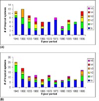
The abundance tropical storms over 5 year periods since 1944 in the (A) eastern Caribbean and (B) western Caribbean. The colored scale refers to the severity of the hurricane, with “ts” being a tropical storm with winds less than 74 mph (the lowest rating) and “h5 “ being a Class V hurricane with winds greater than 155 mph (the highest rating). (From: Carribean Hurricane Network ) |
|
|