
Definitions
Pangaea, Gondwanaland, Laurasia and Tethys
Pangaea
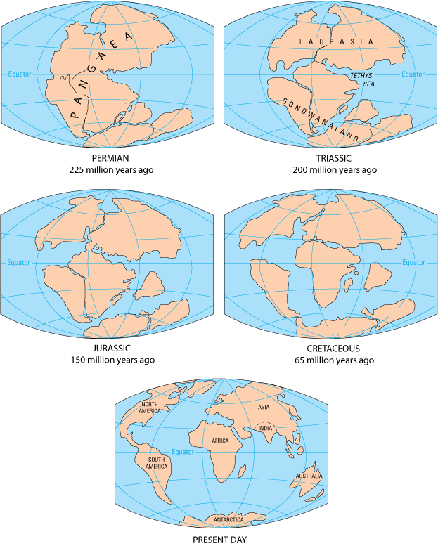
a large supercontinent that existed existed ~225 million years ago at the .. between the close of the Paleozoic and start of the Mesozois (at the Permo-Triassic).
Gondwanaland
a large supercontinent that existed in the southern hemisphere, clustered near the Antarctic Circle, before it began to break up ~200 million years ago, consisting of the modern day continents of Antarctica, India, Australia, South America and Africa.
 Breakup of Gondwanaland
Laurasia
a large supercontinent that existed in the northern hemisphere before it began to break up ~200 million years ago, consisting of the modern day continents of North America, Europe and Asia.
Tethys
an east-west trending ocean that separated Gondwandland from Laurasis.
Comments

Image from U.S. Geological Survey.
The modern continents as we know them were clustered into a single large continent called Pangaea that broke apart by seafloor spreading.
The world geography was not dominated by Pangaea for all time before the end of the Paleozoic. The Earth's plates had probably clumped up more than once in he past and moved apart before clumping up again. That cycle of clumping and reopening of oceans is called the Wilson Cycle. The largest clumped continents such as Pangaea are called supercontinents. There are few guesses about the layout of continents before Pangaea because clues from earlier rocks are difficult to decipher. Tectonic activity not only totally destroys oceanic crust, but it munches up continental crust.
Why give a supercontinent such as Pangaea a special name rather than call it by modern names? We give a unique name to any single continental landmass today. Even though we may think of Pangaea as made up of the seven continents today, it was a unique continent at the time it existed and its existence didn't depend on modern continents.
Gondwanaland is the name of another clumping of continents, one that was large, but smaller than Pangaea and occurring at a different time - at the end of the Mesozoic. When Pangaea broke up, the northern continents of North America and Eurasia became separated from the southern continents of Antarctica, India, South America, Australia and Africa. The large northern continent is called Laurasia and the southern continent is called Gondwanaland. Laurasia and Gondwanaland were separated by an ocean called Tethys that no longer exists today. The long direction of Tethys runs east-west rather than north-south like the Atlantic and Pacific Oceans today. That allowed ocean currents to flow all around the Earth in the east-west direction near the equator, causing the Earth's climate to be very different.
Pangaea
a large supercontinent that existed existed ~225 million years ago at the .. between the close of the Paleozoic and start of the Mesozois (at the Permo-Triassic).
a large supercontinent that existed in the southern hemisphere, clustered near the Antarctic Circle, before it began to break up ~200 million years ago, consisting of the modern day continents of Antarctica, India, Australia, South America and Africa.
Laurasia
a large supercontinent that existed in the northern hemisphere before it began to break up ~200 million years ago, consisting of the modern day continents of North America, Europe and Asia.
Tethys
an east-west trending ocean that separated Gondwandland from Laurasis.
Comments

Image from U.S. Geological Survey.
The world geography was not dominated by Pangaea for all time before the end of the Paleozoic. The Earth's plates had probably clumped up more than once in he past and moved apart before clumping up again. That cycle of clumping and reopening of oceans is called the Wilson Cycle. The largest clumped continents such as Pangaea are called supercontinents. There are few guesses about the layout of continents before Pangaea because clues from earlier rocks are difficult to decipher. Tectonic activity not only totally destroys oceanic crust, but it munches up continental crust.
Why give a supercontinent such as Pangaea a special name rather than call it by modern names? We give a unique name to any single continental landmass today. Even though we may think of Pangaea as made up of the seven continents today, it was a unique continent at the time it existed and its existence didn't depend on modern continents.
Gondwanaland is the name of another clumping of continents, one that was large, but smaller than Pangaea and occurring at a different time - at the end of the Mesozoic. When Pangaea broke up, the northern continents of North America and Eurasia became separated from the southern continents of Antarctica, India, South America, Australia and Africa. The large northern continent is called Laurasia and the southern continent is called Gondwanaland. Laurasia and Gondwanaland were separated by an ocean called Tethys that no longer exists today. The long direction of Tethys runs east-west rather than north-south like the Atlantic and Pacific Oceans today. That allowed ocean currents to flow all around the Earth in the east-west direction near the equator, causing the Earth's climate to be very different.
Questions for thought
- When did Gondwana start?
- Which continents do not have shared species that originated in Gondwanaland connections?
© 2007-2008 Earthguide at Scripps Institution of Oceanography.
All rights reserved.
All rights reserved.