
Home | Underwater Archaeology | Shallow water | Deep water | Surveying | Excavation | Conservation | Publication
Surveying and Mapping
Keeping track of where you found it
Keeping track of where you found it
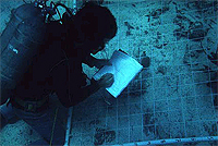
Grids set out on wreck of the HMS Fowey, Biscayne National Park.
Image courtesy Florida State University.
How do you take notes underwater?
To think about:
Can you find buried objects made of other materials like glass or wood? What kind of new tool would you invent?
Like a crime scene, the way in which artifacts are scattered on the ground may reveal important clues, so archaeologists are careful to record the location of all objects before removing or even touching these objects.
Even underwater, archaeologists lay out a grid and very carefully survey the site to measure its dimensions and locate all objects within it. Divers use this grid to note the locations, orientation, depth, and relationship to other objects of all artifacts they encounter. Each item, whether a chamber pot or a piece of a building foundation, is carefully sketched and given a unique identifying number before it is disturbed in any way.
Space (or "spatial) relationships are important not only with respect to horizontal distribution, but in the vertical direction. Horizontal relationships might reveal how things were arranged in space at a particular moment in time, but vertical relationships can reveal relationships of objects over time. For example, in Venice, Italy, people kept building upward as the city of Venice sank, so progressively older artifacts are found by digging deeper.
At the Ocean Institute
Students and visitors to the Ocean Institute can try their skills at using a magnetometer to find buried artifacts.
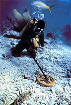 Diver using a magnetometer to scan a shipwreck. Image courtesy Institute of Nautical Archaeology. |
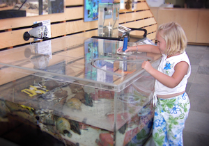 Magnetometer at the Ocean Institute. Visitor looking for buried artifacts in the test tank. Image from the Ocean Institute. All that you can do at OI |
Where to find more information:
The Port Royal Project
Can you identify shallow water mapping and surveying techniques used at Port Royal?
Donny L. Hamilton, Nautical Archaeology Program, Texas A&M University.
DeepArch
Can you identify deep water mapping and surveying techniques used by DeepArch?
MIT
An Introduction to Marine Archaeology
More about underwater archaeology.
By Colin Martin, BBC
Archaeology
Basic information about archaeology and several good examples. Can you identify challenges that are common to both land-based and underwater archaeology?
BBC
Shipwreck!
More about wreck formation, surveying, measuring and excavation.
from Shipwreck!, a former exhibit at the Miami Museum of Science
Produced in collaboration with Scripps Institution of Oceanography.
Website by Earthguide.
© 2003-2004 by the Ocean Institute
and the Regents of the University of California.
All rights reserved.
Last modifed Monday, December 10, 2004