Note - This is a quick and informal guide to tsunami, including links to resources about the recent tsunami in the Indian Ocean. It includes a brief introduction as a jump start into the overall subject and current events. I hope it serves as a springboard for you to learn more from the about tsunamis from the experts (which I am not). I'll post other things as I find out about them and I'll make corrections if needed. - Memorie Yasuda, Earthguide myasuda@ucsd.edu Tsunami basics What is a tsunami? A tsunami is the great wave of seawater triggered by the sudden displacement of a large volume of water in the ocean. Once they start, tsunami waves radiate across oceans, far from their places of origin. In some instances they transmit destructive energy to coastal areas when they land. What seems like a small wave out at sea becomes a large one closer to land. 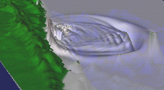 See how the waves generated in this event might have radiated out from their source. The "ripple" pattern isn't a perfect ring because of irregularities in the shape of the sea floor. If the output of a simulation looks like what actually happened, we may be on the right track to understanding tsunami. Imperfect as it might be, the output of a simulation, as the sum of our existing knowledge, may be the best longterm predictive tools we have to use in deciding what to do about unforeseeable future events. Image and movie courtesy U.S. Geological Survey Tsunami are fast, but not so fast that a phone call couldn't send warning to most places. But in areas that happen to be very close to the origin, warning and response systems may not be able to outrun the arrival time of tsunami. Tsunami are just one type of ocean wave among several. Everyday waves at the top of the ocean are those generated by wind rather than the causes of tsunami. Tsunami are triggered by any event that results in rapid displacement of seawater. These events include:
If tsunami look so wimpy out at sea, why are they so destructive when they arrive at the coast? Wind waves in the open ocean are commonly several tens of feet tall. Tsunami waves are usually less than a few feet high. Wind waves may look more impressive than tsunami in the open ocean, but tsunami can apply a much more concentrated burst of force at the coast. Tsunami transmit very large amounts of energy. Wind waves contain energy involved in the motion of water confined to a layer not much deeper and thicker than 100 meters. Tsunami motion involves the entire column of water as they pass. That can involve motion of more than 6,000 meters of water in the ocean. Can you imagine your energy bill if you had to pay to move that water even just a little? As tsunami approach the shore, they are slowed by greater interaction with the ground as the ground shallows. The motion of water amplifies when energy in tsunami becomes concentrated in shallower water. As tsunami run up onto land and bounce around, energy is dissipated through often destructive processes. Eventually energy is fully dissipated and the sea is restored to its normal state. Do all large earthquakes result in tsunami? Not necessarily. Since water needs to be displaced, an earthquake must cause the ground underneath the ocean to move. Even when this condition occurs, strong tsunami may not form because of other circumstances. Think of all the variables that result in the qualities of ripples in a pond. What are the factors that make the differences in ripples, whether a rock is dropped directly from above or that same rock is skipped across its surface? The factors controlling the size, shape, speed, and landing of tsunami are complex. The qualities of tsunami are the result not only of the triggering event, but what lies along its path. Earthquake detection and tsunami detection are not the same thing. Earthquakes around the world are relatively easy to monitor and detect. Tsunami are not so easy to detect and confirm. Whether tsunami were generated is a separate question and must be checked out independently. Besides, it might not be a good idea to rely on major earthquakes as the only heads-up for tsunami because other events also cause tsunami. How are tsunami detected? 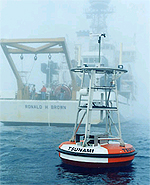 DART tsunami warning equipment.
Click here for more information about the DART project. Image courtesy Pacific Marine Environmental Laboratory (PMEL), NOAA. Even killer tsunami are difficult to detect as they move across the open ocean. Sensitive instruments are required because passing tsunami affect sea level by about a meter over wavelengths that are tens to hundreds of kilometers long. Could you even sense a slope in the surface at this scale? Plus, the waves of tsunami are lost like background noise in a sea of much larger wind waves. Sensors may make the pressure measurements, but the data must also be processed to sort things out. An open ocean sensor wouldn't have done any good until recently because someone would have had to take readings. Even if that someone had sailed off to do their work, waiting for their return wouldn't be very timely. Today, sensors deployed on the bottom of the ocean transmit data in practically real-time to inquiring minds on land. Underwater sensors are linked to buoys at the sea surface that transmit to satellites. From there, information travels as fast as a phone call to wherever people decide it is needed. Once they have data from observations at sea and combine it with other relevant information, people along the chain of tsunami warning systems can decide what to do. Most importantly, they can pass this information along to people who might be in the path of danger. All of this wouldn't be possible without having the knowledge and technology that exists today. How do we know which coastal areas will incur the most loss? 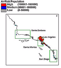 Efforts to estimate areas at risk.
Click here for more information from the Center for Tsunami Inundation Mapping Efforts. Image courtesy National Tsunami Hazard Mitigation Program, NOAA. In places where causes of tsunami are likely, like the Pacific Rim where offshore earthquakes are common, scientists use computer models to simulate tsunami to see what might happen. The models themselves are compact reprsentations of how we think tsunami work. In running a "simulation", conditions for a hypothetical triggering event are input to a computer model, then the model is allowed to run or compute the changes in sea level that would be triggered over time. The output of these calculations are often output as pictures or "visualizations" so we can see what might happen. The movie at the top of this page is such a visualization. The movie shows how a tsunami radiates out from the source, when it arrives at different shoreline locations, and how high water will get at particular places. Since this simulation replicates an event that has actually happened, scientists can compare the model output with actual observations to see how well the simulation served as a prediction of the real event. If there's a major difference, they can work to improve the model. Simulations are not images of actual events, but they can be useful in planning and to gain new insights into tsunami. What to do next? Learn more and do what you can to help today and in the long run. |
||||||||
|