Making connections
Parallels between continent and seafloor
Barbara John said what this expedition tells her is that coming to sea in search of simpler parallels to some very complex continental geology can itself be "an oversimplification."
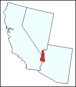
Ashore, one of John's major field sites is located besides the Chemehuevi Indian reservation along the Colorado River's California side. After years of study there, the University of Wyoming professor thinks she has recognized what might be the final outcome of what is called "Basin and Range" geology.
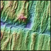
Fig. 1. Location of Chemehuevi Indian reservation along the Colorado River.
The Basin-and-Range Province, a band of topography extending from Mexico to Canada, is a classic kind of repetitive landscape where steep-sided mountain ranges alternate with flat, sediment-filled valleys along a section of the North America west of the Rocky Mountains.
Visitors to the United States' desert Southwest may have driven through it without really noticing the repetitive pattern, as the highway rises steeply up a sharp grade, levels off to a plateau, drops equally steeply, then levels off to flatlands, over and over again.
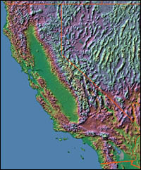
Geologists think the reason is crustal stretching over the past 6 million years, she said. That has caused some blocks of ground to drop - the basins - and adjacent blocks to rise - the ranges - along steeply dipping below ground normal faults.
Fig. 2. Relief map of Basin and Range topography. Areas of Nevada show this stype of topography most clearly although it extends into the southeastern part of California. © 1995 Ray Sterner, Johns Hopkins University Applied Physics Laboratory, http://fermi.jhuapl.edu/states/.
In a conversation aboard the R/V Atlantis, John said her desert research site, part of the Colorado River Extension Corridor, encompasses land that does not actually have the classic basin-and-range topography.
Instead there is an alternate pattern, with a region of almost undisturbed crust on each end and a region of extension in between. And within that extended, outwardly dipping section, a series of faulted hills surround a central dome. "It's like a muffin with faults around the muffin," she added.
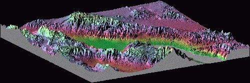 Fig. 3. The look of Basin and Range topography - an oblique 3D relief map of Death Valley National Park, California / Nevada. © Ray Sterner, Johns Hopkins University Applied Physics Laboratory, http://fermi.jhuapl.edu/states/.
She called that dome-shaped "muffin" a "detachment," a block of crust that has been separated from the blocks around it - the surrounding hills - in a particular way. She and other similarly thinking land-based geologists believe that underlying it all is an unusually gently dipping "normal" fault called a "detachment fault."
They call that particular geological arrangement a "continental core complex."
Acknowledging that some fellow experts disagree with her, John thinks a continental core complex is the result of extreme (more than 100 percent) stretching: "the basin and range gone wild," she said.
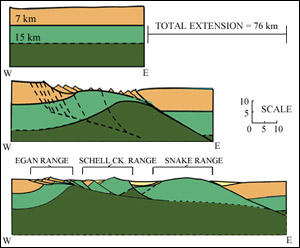
Fig. 4. Schematic cross sections of continental core complex formation in the Basin and Range.
Diagram adapted from Blackman et al., 1998 from Wenicke, 1992.
|
The older Colorado River Extension Corridor, which dates to the Miocene period between 12 and 20 million years ago, stretched a lot more over a similar, or perhaps somewhat longer, interval than the classic basin-and-range has done recently.
John was invited to join marine-oriented geologists on this cruise to evaluate a working hypothesis: that the "muffins" she studies ashore act much like the "footwall" proposed to be rising at the underwater mountain far below the R/V Atlantis' hull.
Extending that analogy, the hills surrounding one of the central domes in the Colorado River Extension Corridor would fill the role of the displaced hanging wall at the submerged mountain, which is also domed on top.
If this is the case, the footwall to the Mid-Atlantic Ridge mountain would be sliding out from under the hanging wall along a normal fault pitched at a relatively low angle - lower than is the case for classic Basin-and Range extension faults, John said.
But instead of a continental core complex, this massif would be formed under its marine equivalent rules of design- called an "oceanic core complex - where the driving forces include spreading ocean plates
After having to evaluate up to 1.7 billion years of geological history at some of the sites she studies ashore, John said she jumped at the chance to study a structure that may not only be simpler but more directly accessible and much younger - on the order of 1½ million years.
"I couldn't resolve some of the complicated problems on the continents," she said. So John had hoped a similar geological setting in the ocean would give her a fresh set of clues.
Today's pages:
Drawing parallels | Where's the fault? | Further evidence needed

|