Remote viewing with DSL-120
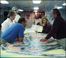
Fig. 5. Members of the research team going over upcoming dive plans. Clockwise starting the Jeff Karson in the blue shirt, Debbie Kelley, Tim Schroeder, Donna Blackman, and Joe Cann.
"That's a reason why we came down here," John acknowledged as the DSL-120 side-scan sonar crisscrossed another part of the massif - 2,190 meters behind and below the ship at a depth of 2,060 meters - looking for rock outcrops and tell-tale signs of the dome's underlying geology. "Joe and Donna recognized the corrugations and suggested they might be a fault surface."
Sitting in the dim light of the DSL-120's control van, John said she and Cann actually have a "Bermudian quarter" wager over the location of the illusive fault where the hanging wall and footwall meet. Periodically, she stopped talking to write down and plot locational information relayed by Heather Hanna, a Duke University graduate student. Hanna read the data off a glowing monitor near the chair of Thomas Crook, a DSL navigator. Left of Crook, DSL pilot James Varnum was reeling the side-scan's tow cable in and out to keep the device about 100 meters above the mountain's surface at the speed of 1 knot.
 While Varnum and Crook controlled the sonar, it was up to John, Hanna and other members of the science team behind them to monitor, log , map and tape the data streaming in on this DSL watch, one of three shifts that followed the sonar's every move around the clock. Meanwhile Cann, this shift's watch leader, was shining a light on the paper tape that constantly unrolled the sonar's ghostly images in wispy patterns of white, grey and black. "This is amazingly complicated terrain," he exclaimed.
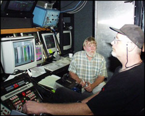
Fig. 6. [right] Tim Crook (left) of Woods Hole's Deep Submergence Laboratory serving as DSL-120 navigator while James Varnum (right) of DSL pilots.
Each watch ran for four hours twice a day. So the same group of scientists covering the 4-8 p.m. watch, for example, would also stand another from 4-8 a.m. Since most researchers sleep two to a stateroom, that made life more complex - let alone exhausting - as roommates began setting alarms for drastically different times.
After its shaky start, the DSL-120 ended up being towed more than 120 miles over 3½ days and nights without letup. And Blackman found herself constantly redrawing the routes in response to previous positive or lackluster results. In the end, she pronounced it "a really good survey" when this "fish" was reeled in for now at 8 a.m. on Monday, Nov. 20th to allow as many Alvin dives as possible within her allotted 14-day maximum.
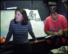
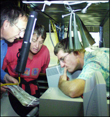
Fig. 7. [left] Heather Hanna (left) reading off navigational data to Barbara John.
While not all the massif received sonar sweeps, the new scans served to embellish those of Tobi data collected more than four years earlier, she noted. The two separate surveys are "very complementary," Cann added. And "they're agreeing."
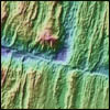
 What the new side-scan images showed were craggy fingers of outcropping rock along the south flank that would make good targets for Alvin dives. There are some outcrops to the east too. The trademark corrugations along the dome's top are also well-imaged. And there are what look like two small volcanic craters over the hanging wall. But a large area of sediment - Cann called it "mud" - overlies much of the north and northeast, including the suspected edge of the detachment fault. "Mud is covering useful geology," Cann said.
Fig. 8. Joe Cann, Barbara John, and observer Bruce Applegate discussing paper printout of DSL images.
Argo II - the scout
With DSL-120 out of the water it was time to launch Argo-II, which was first eased over the port side after dusk on Tuesday, Nov. 22, using the same crane that launched the side-scan. The first of two dark-hour shifts convened shortly afterwards in the reconfigured control van.
With the sonar already providing enough information to plan for Alvin dives, Argo will be sent down most nights on a quest for the best camera panoramas. It will then return before the submarine is launched the following mornings for rock collecting, gravity studies and first-hand observations. To maximize that amount of daylight, the ship's clocks were set back an additional hour - to 3 hours ahead of Eastern time.
Today's pages:
The Moving Earth | Faulting | DSL-120 and ARGO-II | Bringing Out Alvin | Thanksgiving Day

|

|
|